California’s Sustainable Groundwater Management Act (SGMA), now in its 10th year, changed how groundwater is managed statewide. Groundwater Sustainability Agencies (GSAs) were formed to develop and implement Groundwater Sustainability Plans (GSPs). A required section of a GSP is Sustainable Management Criteria (SMC), which identifies the minimum thresholds, measurables objectives, interim milestones, and undesirable results for each applicable sustainability indicator. One of the most challenging sustainability indicators is subsidence management.
Montgomery & Associates has prepared or helped prepare GSPs in 20 basins and has become well-versed in SMC and sustainability indicators. In the case of the Kaweah Subbasin, which is developing approaches to minimize subsidence as part of its GSP implementation, M&A led a subsidence analysis using a novel method to couple subsidence and groundwater level management targets and assess how projects and management actions can achieve the targets.
The Importance of Residual Subsidence
Subsidence can continue even while groundwater levels stabilize or rise. Delayed subsidence, commonly known as residual subsidence, occurs because of a lag in pore pressure equilibration of thick, low-conductivity clay layers. Parts of the San Joaquin Valley will almost certainly continue to subside for decades after groundwater levels stabilize because of residual subsidence. Future subsidence could be minimized but will require a significant, coordinated, regionwide effort to recharge deep aquifers and reduce groundwater pumping in the most critically subsiding areas.
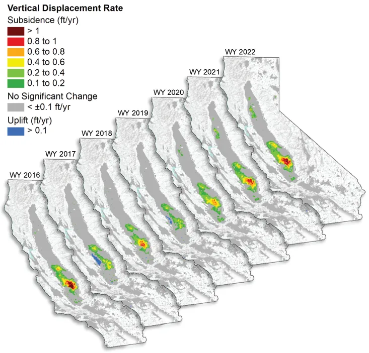
Groundwater overdraft in the lower aquifer below the regionally extensive Corcoran Clay is the primary cause of subsidence in the Kaweah Subbasin (Lees et al., 2022). Subsidence has accelerated in much of the region in the last couple of decades due to ongoing overdraft, particularly during the 2012-2015 and 2020-2022 droughts. Even in wet years when there is some groundwater level recovery, residual subsidence causes the land to continue to sink. Data collected by the California Department of Water Resources (DWR) show that the area around the Kaweah Subbasin has had the highest subsidence rates in the state since 2015, occasionally exceeding
1 foot/year.
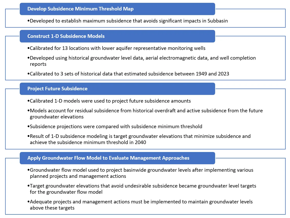
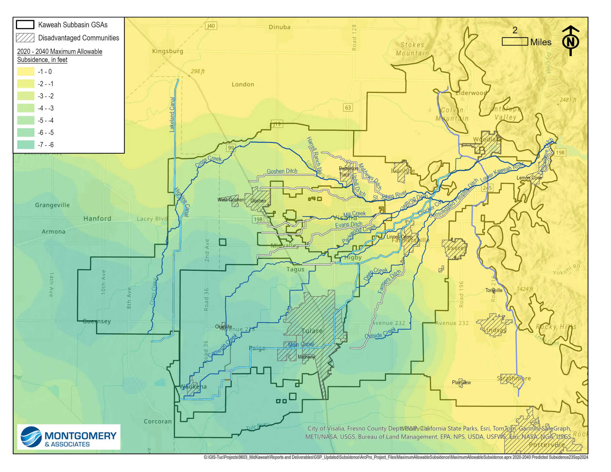
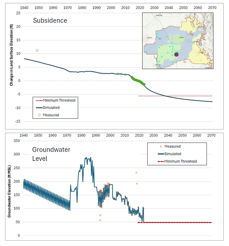
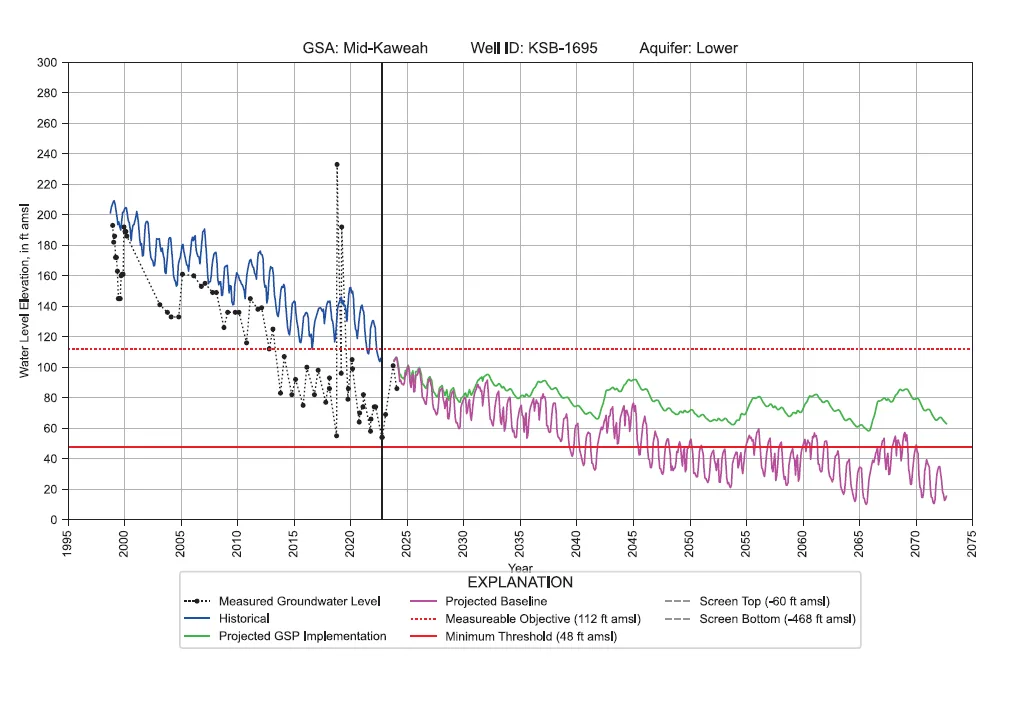
To minimize subsidence, the Kaweah Subbasin GSAs must manage groundwater levels beneath the Corcoran Clay based on estimated future subsidence impacts. M&A established subsidence targets through a series of technical analyses linking subsidence to projected groundwater levels:
The coupled groundwater flow model and 1-D subsidence model identify the actions needed to meet sustainability under a range of future scenarios. The results confirm that achieving groundwater level and subsidence SMC is possible in the Kaweah Subbasin with aggressive action. The models project that future pumping from the lower aquifer, especially from deep supply wells, needs to be curtailed to prevent overdraft in the lower aquifer. The GSAs are using the analysis to advise local and regional partners that alternative options must be developed quickly to minimize and slow subsidence.
In addition to assisting GSAs that aim to evaluate and minimize subsidence in their basins, M&A professionals can use their expert modeling and data analysis skills for a range of hydrogeology and water management projects. We offer the largest, most experienced groundwater modeling team in the western United States, with 20 professionals who are proficient in a variety of numerical groundwater flow and transport codes. Our predictive models can incorporate future uncertainties such as climate change or estimated future urban and agricultural water demand through scenarios or probabilistic simulations. We often use 3-D geologic models to develop input and present results in a way that is accessible to project stakeholders. Our SGMA experts are adept at communicating complex modeling results to GSAs and interested parties to support long-term decision making for sustainable groundwater management.
References
DWR, 2023. California’s Groundwater Conditions: Semi-Annual Update. April 2023.
Lees, M., Knight, R., & Smith, R. 2022. Development and Application of a 1-D Compaction Model to Understand 65 Years of Subsidence in the San Joaquin Valley. Water Resources Research, https://agupubs.onlinelibrary.wiley.com/doi/10.1029/2021WR031390
About the Authors
Pete Dennehy, P.G., C.Hg., is a senior hydrogeologist in M&A’s Sacramento office. He has provided technical analysis and project management on several of M&A’s GSP projects.
Derrik Williams, P.G., C.Hg., is a principal hydrogeologist in M&A’s San Luis Obispo office. He worked closely with the California Department of Water Resources to develop the state’s SGMA implementation process and has overseen M&A’s work on several GSPs.

