The Montgomery & Associates Data Management System (M&A DMS) is the engine that powers the Salinas Valley Basin Groundwater Sustainability Agency’s (SVBGSA) progress towards sustainable groundwater management. As a component of its Groundwater Sustainability Plans (GSPs), SVBGSA is required by California’s Sustainable Groundwater Management Act (SGMA) to develop and maintain a data management system capable of storing and reporting information relevant to the development or implementation of the GSP and monitoring of the basin. By providing a platform to compile and organize data for wells and other monitoring sites, the M&A DMS facilitates the upload of GSP and Annual Report data to the California Department of Water Resources (DWR). The DMS contains location and construction information and other fields required by SGMA for wells and other sites. It also includes related time-series data for groundwater levels, groundwater quality, and surface water flows, which allow the GSA to efficiently monitor groundwater conditions and sustainability criteria in the basin.
Customized Access
In addition to facilitating data management and reporting to the state, the M&A DMS allows SVBGSA to share data with GSP stakeholders and the public through a custom web portal interface. This web portal includes web maps, document libraries, and data export applications, each with security options to allow certain data to be viewed by selected users. Access to the full project DMS is restricted to SVBGSA staff due to the confidentiality of certain groundwater well information; however, through a public login, stakeholders and the public are able to access the portal to view a web map that includes non-confidential monitoring site and time-series data. With GIS layers built in, users can view the groundwater conditions and political and hydrogeologic characteristics of the plan area. Time-series charts, search and export tools, and drawing and measurement functions allow users to further interact with and visualize the data.
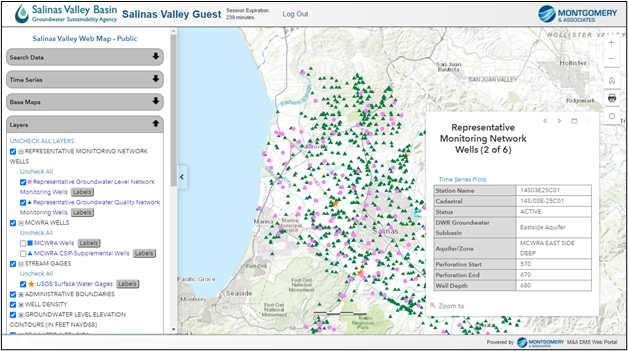
Public web portal map for SVBGSA’s DMS
These tools promote transparency and facilitate communication among GSA staff and GSP stakeholders. In September 2020, SVBGSA and M&A hosted an online Web Map Workshop, in which stakeholders were introduced to the web portal, completed tutorial activities to gain familiarity with the site, and collaborated in groups to complete two activities using web portal tools. The portal has also been used in other public meetings to present information related to the GSP and to identify potential recharge sites in the field. To view this public map, visit https://svbgsa.org/gsp-web-map-and-data/, click the “Salinas Valley GSP Web Map” link, and log in with the specified credentials.
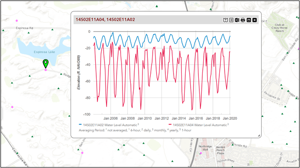
Water level elevation change over time for two monitoring wells
Broader Applications
The M&A DMS is customizable and can be used for a wide range of projects beyond GSP development. On a new DMS project, M&A’s database team works with the project sponsor to identify the purpose of the DMS and design a database structure. The M&A team then imports relevant data, much of which usually comes from publicly available sources and in-house proprietary datasets, performs quality assurance and quality control, and creates a customized online map to display the data. The different map functions, such as the well pop-up windows and time-series charts, are customized to meet project needs by specifying which well data fields and related time-series data tables and date ranges are accessible according to confidentiality or regulatory requirements. Once the base map has been designed, approved users can log in to the portal and interact with their data. Users can create customized maps by turning layers on and off, changing base maps, and selecting parameters. Custom time-series data charts can be generated for specified time ranges and measurement types in real time and shared with managers, the public, and the project team to assist with communication and decision making.
Other Features
Also included in the M&A DMS is a document library to store and organize well records, photos, and reports to facilitate the archiving, accountability, and accessibility of data. Documents that are related to specific geographic points, such as monitoring wells, can be viewed directly from the web map. The data export tool allows users to query and export data using client-defined search parameters. Multiple web maps can be offered to cover unique sites/facilities or allow varying degrees of user access to data.
The M&A DMS is integrated with Collector and Survey123, powerful field-based data collection applications. Once surveys and photos have been collected using electronic tablets in the field, surveys and photos can be uploaded to the M&A DMS, displayed on the web map, and exported through the data export tool. M&A has used this capability on a variety of projects including well inventories and surveys, stream and riparian monitoring, and general field operations tracking. Telemetry data can also be integrated with the M&A DMS, allowing users to access real-time monitoring data through the web portal.
M&A offers the DMS tool as a standalone service or an add-on to any project. We offer training to all users, and we host and maintain the project databases, providing ongoing technical support. We always welcome input from users and readily respond to requests for customization and updates.
For more information and to view an example M&A DMS, visit our Data Management Services page or contact Staffan Schorr, principal hydrogeologist and manager of M&A’s Data Management Services.
About the Authors
Michael Levengood is M&A’s GIS and data coordinator. He implements protocols for GIS and data management, coordinates GIS production and project data deliverables, and manages web-based data and mapping applications. Prior to joining M&A, he taught online courses for the University of Arizona’s GIS Technology master’s degree program and worked as a planner and GIS specialist with the City of Tucson. Michael is fluent in Spanish and has experience teaching Spanish and English language courses in both the United States and Chile. Michael has also worked as a technical writer, editor, and translator and has published academic articles in diverse fields.
Staffan Schorr is a principal hydrogeologist and manager of M&A’s data management services. He applies his background in numerical and analytical groundwater flow modeling to a variety of M&A projects to simulate the effects of mine dewatering, managed aquifer recharge and recovery, and long-term pumping. He has extensive experience using GIS methods to develop numerical model inputs, display model results, and develop geospatial databases for conceptual hydrogeologic models. His other interests include characterizing the interactions between groundwater and surface water along riparian corridors.