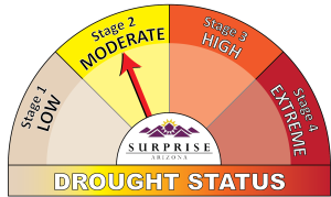
M&A determined that the hydrologic drought triggers in the City of Surprise are CAP availability, groundwater conditions, drought status, and projected water supply compared to demand.
City of Surprise
OVERVIEW
As required by the state of Arizona, the City of Surprise and other water providers within the City’s Municipal Planning Area (MPA) prepared a Drought Preparedness Plan (DPP) in 2008. In the face of pending shortages on the Colorado River and increasing development and groundwater pumping within its boundaries, the City decided to work with its neighboring water providers to evaluate groundwater conditions and update the DPP.
SERVICES
M&A developed a web portal with a hydrograph creation function, providing an instantaneous look at the current status and historical trends for drought evaluation. The drought team can use these snapshots to evaluate the overall picture and then, using the data in the web portal, look closer at other wells and recharge activities in each area. This evaluation along with the other drought indicators will allow the City to make an informed decision on drought status at any time.
Web Hosting & User Interfaces
- Developed a custom web map utilizing the M&A data management system (DMS).
- Outlined a data collection and record-keeping protocol for all water providers in the city to standardize groundwater level measurements and evaluation of trends.
Climate Change & Drought Planning
- Evaluated all available groundwater data and selected a subset of wells that can be used to evaluate trends for drought status monitoring.
- The proposed drought status for the City of Surprise is based on four criteria that are evaluated in combination to determine drought stage and trigger corresponding drought response actions.
- Prepared drought triggers and developed a simple graphical annual report that provides a snapshot of aquifer and drought conditions for communication to the public.